
Art in Science: How Innovative Images Led to a 'Miraculous' Revolution in Neurology
- -
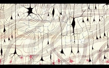
Complete video at: http://fora.tv/2011/03/14/Carl_E_Schoonover_Portraits_of_the_Mind Carl Schoonover, author of Portraits of the Mind: Visualizing the Brain from Antiquity to the 21st Century , describes the "miraculous" revolution that occurred in neural imaging during the late 19th century. Because of the work of two men, he explains, our ima... Read more
0 people like this
- -: Art in Science: How Innovative Images Led to a 'Miraculous' Revolution in Neurology
January 23, 2012 (over 12 years ago)Complete video at: http://fora.tv/2011/03/14/Carl_E_Schoonover_Portraits_of_the_Mind Carl Schoonover, author of Portraits of the Mind: Visualizing the Brain from Antiquity to the 21st Century , describes the "miraculous" revolution that occurred in neural imaging during the late 19th century. Be...
0 people like this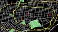
- -: TEDxPhilly - Amy Hillier - Mapping experiences and access to opportunity in cities
January 19, 2012 (over 12 years ago)A pressing issue for Amy Hillier: Why does the place of our birth and child rearing influence the amount of opportunities available to us as adults? Is there something we can do about this? If we could trace our experiences using modern mapping technologies - like GIS, GPS, LiDAR and others - to ...
0 people like this
- -: Erik Hersman: How texting helped Kenyans survive crisis
April 22, 2009 (about 15 years ago)http://www.ted.com At TEDU 2009, Erik Hersman presents the remarkable story of Ushahidi, a GoogleMap mashup that allowed Kenyans to report and track violence via cell phone texts following the 2008 elections, and has evolved to continue saving lives in other countries. TEDTalks is a daily video ...
0 people like this
- -: Lalitesh Kattragadda: Making maps to fight disaster, build economies
January 13, 2010 (over 14 years ago)http://www.ted.com As of 2005, only 15 percent of the world was mapped. This slows the delivery of aid after a disaster -- and hides the economic potential of unused lands and unknown roads. In this short talk, Google's Lalitesh Katragadda demos Map Maker, a group map-making tool that people arou...
0 people like this
- -: Blaise Aguera y Arcas demos augmented-reality maps
February 18, 2010 (about 14 years ago)http://www.ted.com In a demo that drew gasps at TED2010, Blaise Aguera y Arcas demos new augmented-reality mapping technology from Microsoft. TEDTalks is a daily video podcast of the best talks and performances from the TED Conference, where the world's leading thinkers and doers give the talk o...
0 people like this
- -: Tactile Maps Automated Production (TMAP)
October 9, 2007 (over 16 years ago)Google Tech Talks October 12, 2006 Dr. Miele is an alumnus of the University of California at Berkeley where he received his BA in Physics and his Ph.D. in Psychoacoustics. He is currently a Research Associate at The Smith-Kettlewell Eye Research Institute's Rehabilitation Engineering Research C...
0 people like this
- -: A General Approach to Discovering, Registering, and Extracting Features from Raster Maps
September 1, 2010 (over 13 years ago)Google Tech Talk August 25, 2010 ABSTRACT Presented by Craig Knoblock. Maps can be a great source of information for a given geographic region, but they can be difficult to find and even harder to process. A significant problem is that many interesting and useful maps are only available in ras...
0 people like this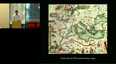
- -: Worlds Upon Worlds: An Illustrated Talk by Toby Lester
September 2, 2010 (over 13 years ago)Google Tech Talk August 23, 2010 ABSTRACT Toby Lester -- a longtime editor and writer for The Atlantic, and the author of The Fourth Part of the World (2009) -- will be here to talk about what may well be the greatest map ever made: the Waldseemüller world map of 1507. A giant wall map recently...
0 people like this
- -: Wired Editor Outwits Google with DIY Aerial Drone
June 11, 2009 (almost 15 years ago)Complete video at: http://fora.tv/2009/05/30/DIY_Drones_with_Chris_Anderson Chris Anderson, editor in chief of Wired, discusses how he outsmarted Google by using his unmanned aerial vehicle (UAV) to map its campus in Mountain View, CA. He also remembers crashing a UAV onto the grounds of the Law...
0 people like this
- -: How American Indians Use Tech to Reinstate Tribal Lands
June 15, 2009 (almost 15 years ago)Complete video at: http://fora.tv/2009/05/04/Eye_in_the_Sky_GIS_Satellite_Imagery_and_Mapping Jhon Goes in Center, Founder of Innovative GIS Solutions, discusses how the Lakota tribe use GIS mapping technology to reestablish tribal land boundaries. Goes in Center compares ancient mapping techniq...
0 people like this